
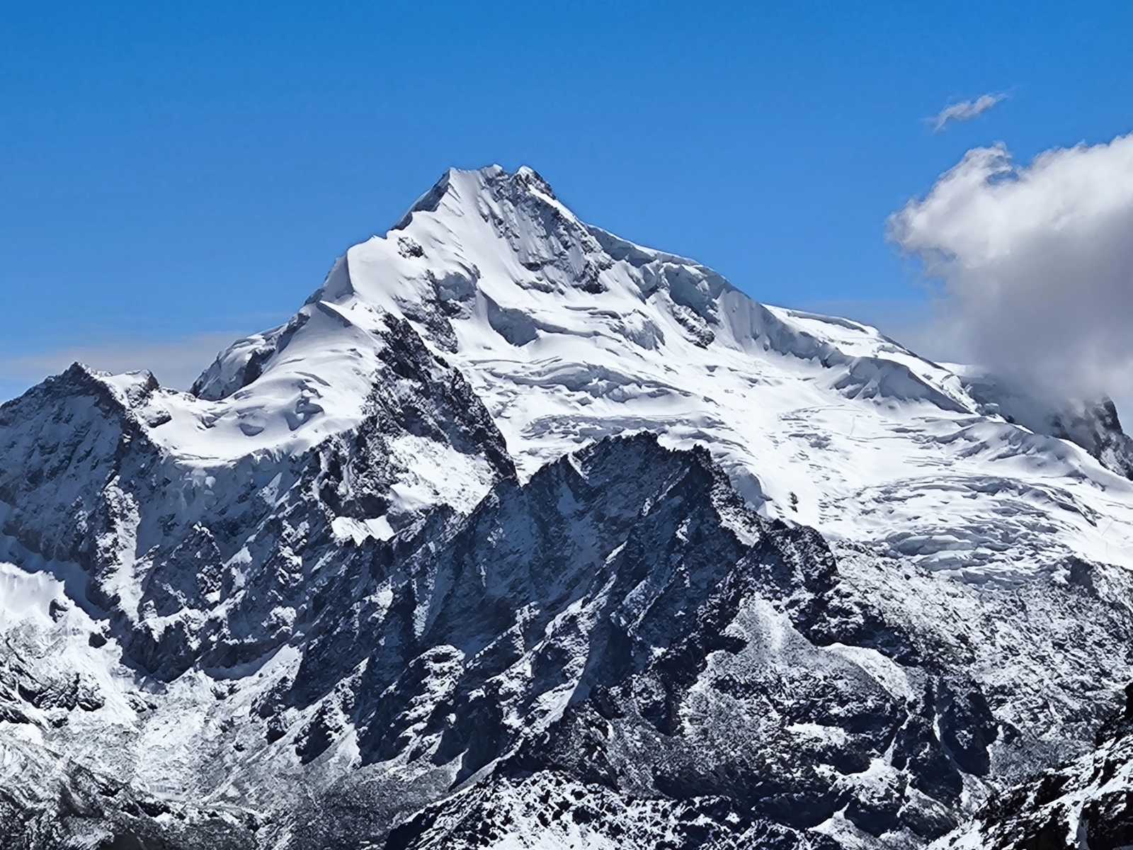
HUAYNA POTOSI 6.088m. THE MOST POPULAR MOUNTAIN IN BOLIVIA.
Technical Data of Huayna Potosí
- Altitude: 6,088 meters above sea level.
- Location: It is situated in the Cordillera Real, in the department of La Paz, Bolivia, approximately 25 km north of the city of La Paz and about 40 km north of El Alto. Its coordinates are 16°15′45″S 68°09′13.5″W.
- Prominence: 1,352 meters.
- Isolation: 61.4 km.
- Parent Range: Andes, Eastern Cordillera of Bolivia, Cordillera Real.
- First Ascent: Completed in 1919 by Germans Rudolf Dienst and O. Lohse (some sources mention Adolf Schulze instead of Lohse).
- Easiest Route: A relatively straightforward glacier ascent, with a UIAA rating of PD. However, it includes an exposed ridge and moderately steep ice sections.
- Other Routes: There are several more technical routes, such as the French Route on the east face (difficulty AD-), the American Route on the west face (difficulty TD), and the Direct Route on the west face (difficulty TD), among others.
- Snow Line: 5,200 meters.
- Climbing Season: From May to September.
Historical Data
- Indigenous Cultural Significance: For the Aymara indigenous peoples, Huayna Potosí was considered a deity, and its glaciers were sacred sources of water. Its name in Aymara means "Young Mountain" (Huayna: young; Potosí: mountain).
- Colonial Era: During the colonial period, the mountain gained importance due to its abundance of precious minerals, and expeditions in search of silver and other metals made it a point of interest for the conquistadors.
- Ascent History:
- In 1877, a group of six German mountaineers attempted to climb Huayna Potosí for the first time. Without proper equipment and with little practical information, their attempt ended in tragedy: four died at an altitude of approximately 5,600 meters, and the remaining two, although they managed to retreat, died of exhaustion upon reaching Zongo Pass.
- On September 9, 1898, an expedition of Austrian mountaineers attempted the ascent again, but after spending five days at 5,900 meters, they were forced to descend.
- Finally, in 1919, Germans R. Dienst and O. Lohse reached the south summit (slightly higher than the north summit) by climbing the east face, via a route that later became the current normal route, with some variations.
- In the following years, other more technical routes were opened: in 1929, Huayna Sur was ascended by Valentino Pizoti and G. Cattoretti; in 1969, the southeast ridge was opened by an expedition led by Rudolph Knot; in 1971, the north ridge was ascended by Curt Saville, Marshall Danker and Peter Williams; in 1974, the French Route on the east face was opened by Thierry Cardon and Alain Mesili; in 1970, the American Route on the west face was opened by Roman Laba and John Hudson; in 1978, the Direct Route on the west face was opened by F. Faure and others; and in 1983, the Triangle Route on the east face was opened by A. Mesili and others.
- Changes Due to Global Warming: In recent decades, the glaciers of Huayna Potosí have retreated significantly due to global warming, losing between two and three meters of ice thickness per year. This has made what was once considered an easy ascent more technical and challenging, due to glacier cracking and steeper faces.
Climbing Itineraries
3-Day Itinerary
- Day 1: Departure from La Paz to the base camp, located at Zongo Pass at an altitude of approximately 4,700-4,800 meters, which takes about 2 hours by car. After lunch, a practice session on glacier climbing techniques, such as the use of crampons, ice axes and roping up, is conducted. Spend the night at the base camp.
- Day 2: Ascent from the base camp to the high camp, situated between 5,200 and 5,300 meters above sea level, which takes between 2 and 3 hours. Spend the afternoon resting and preparing for the final ascent.
- Day 3: Depart very early, generally between midnight and 2:00 AM, towards the summit. The route has an average slope of 35° to 40°, and there is a 50-meter-long section with a slope of 55° to 60° starting from 5,500 meters. The ascent takes between 4 and 7 hours. After reaching the summit (around 6:00 or 6:30 AM), rest for about 10 minutes and begin the descent to the high camp in 2 hours, and then to the base camp in an hour and a half. From there, return to La Paz, arriving around 2:00 PM.
2-Day Itinerary
- Day 1: Departure from La Paz to the base camp at Zongo Pass (4,700-4,800 meters). After lunch, ascend to the high camp (5,130-5,300 meters) in 2 to 3 hours. Spend the night at the high camp.
- Day 2: Depart early, between midnight and 3:00 AM, towards the summit. The route is similar to the 3-day itinerary, with an ascent duration of 4 to 6 hours. After reaching the summit, rest and begin the descent to the high camp and then to the base camp, from where you return to La Paz in the afternoon.
1-Day Itinerary
- This is a more demanding option, only recommended for highly acclimatized climbers in good physical condition. Depart from La Paz very early to the base camp at Zongo Pass (4,700-4,800 meters). Begin the ascent directly towards the summit, without spending the night at the high camp. The route can be the normal one or a more technical one such as the French Route. The ascent takes between 6 and 8 hours, and the descent between 4 and 6 hours. Return to La Paz in the evening or early the next day.
It is important to note that climbing Huayna Potosí requires good altitude acclimatization, proper equipment and, preferably, the company of a certified guide to ensure safety. Additionally, weather conditions can change rapidly on the mountain, so it is important to be prepared for any eventuality.